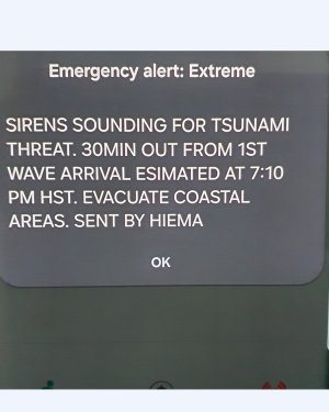
Tsunami Warning For Hawaii Waves to hit ~7:00 PM Local Time

trenchfoot

Lifer
Aug 5, 2000
15,648
8,193
136
We are now in the process of evacuating our shop at Barber's Point. The shit's real, the sirens are blaring and everyone's dropped what they're doing and going home. I'm helping my boss move his boat out of the harbor. Thank goodness my home is well away from the flood zone.
 

IronWing

No Lifer
Jul 20, 2001
72,402
32,976
136
The Tsunami Warning Center is estimating the magnitude of the wave at 0.9m in the open, deep ocean. That is a big f’in’ wave.
 

BoomerD

No Lifer
Feb 26, 2006
65,994
14,397
146
I’m right on the WA coast. We’re expecting it to hit here around 11:30 pm…but only 12 to 18 inches of height, and right after our normal low tide.
 
  • Like
Reactions: hal2kilo

trenchfoot

Lifer
Aug 5, 2000
15,648
8,193
136
This is what we've been getting on our phones and TV's with half-hourly siren intervals. HIEMA is the Hawaii Emergency Management Agency. It's now 6:53 PM HST.

edit - I think there's going to be a rush for a vantage/photo op point at Diamond Head Lookout cliff where the road is about a hundred yards higher than the sea.

tsunami alert.jpg
 
Last edited:

trenchfoot

Lifer
Aug 5, 2000
15,648
8,193
136
I’m right on the WA coast. We’re expecting it to hit here around 11:30 pm…but only 12 to 18 inches of height, and right after our normal low tide.

I may be mistaken, however as I understand how tsunamis work, it's the surge of water behind the wavefront that's going to wreck things along the coastline, along with the follow-up surges the pile up on top of the first one. We're all hoping for minimal effects of the tsunami, but Mama Nature has a way of being fussy and unpredictable about her moods.
 

trenchfoot

Lifer
Aug 5, 2000
15,648
8,193
136
OK, may be a bit premature to call it, but it looks like Hawaii dodged the bullet. It seems the focus of the energy coming out of the earthquake is away from Hawaii. Some minor surge flooding occurred in isolated areas of the state but nothing of note to report.

Still not officially over yet out of caution being practiced by state officials, but looking good so far.
 
Dec 10, 2005
28,071
12,696
136
Sounds like the waves weren't too high from current reports; however, now a volcano is erupting on the Kamchatka peninsula.
 

nakedfrog

No Lifer
Apr 3, 2001
62,003
17,779
136
Interesting timing on reversing this decision…

https://www.npr.org/2025/07/31/nx-s1-5487238/navy-reverses-decision-weather-satellite-hurricanes

Defense Department will keep sharing data for hurricane forecasting : NPR
It seems like they're being very opaque about the reasoning.
But after feedback from government partners, officials found a way to meet modernization goals while keeping the data flowing until the sensor fails or the program formally ends in September 2026.
I was curious to know what sensor it is they're talking about. That article links to this one, which could potentially be more enlightening. Still no information on the sensor, and this is a seemingly conflicting statement?
The Navy did not respond to questions about why it has stopped sharing the data with scientists and forecasters.

A spokesperson for the U.S. Space Force, which is responsible for the satellites, said in a statement that the satellites and instruments are still functional, and the Department of Defense will continue to use them even as it cuts off access for scientists.
But as one continues to read... I begin to have my own suspicions.
The Defense Department satellites were also the main source of real-time information about changes to sea ice.
Sea ice data is important for a lot of reasons. Permanent sea ice in the Arctic and Antarctic is shrinking rapidly because of climate change, and the exact amount of ice fluctuates dramatically over the course of each year.
Now, as a result of the Defense Department's decision, six widely used datasets about sea ice at both poles will be interrupted, according to the National Snow and Ice Data Center.
And who knows how long this backup plan will be feasible...
Serreze's team had already planned to switch to an alternate source of sea ice information: a sensor on a satellite operated by the Japanese government. The U.S. has access to data from that sensor through an agreement between NASA and the Japanese government's space agency.